Guide
Historien
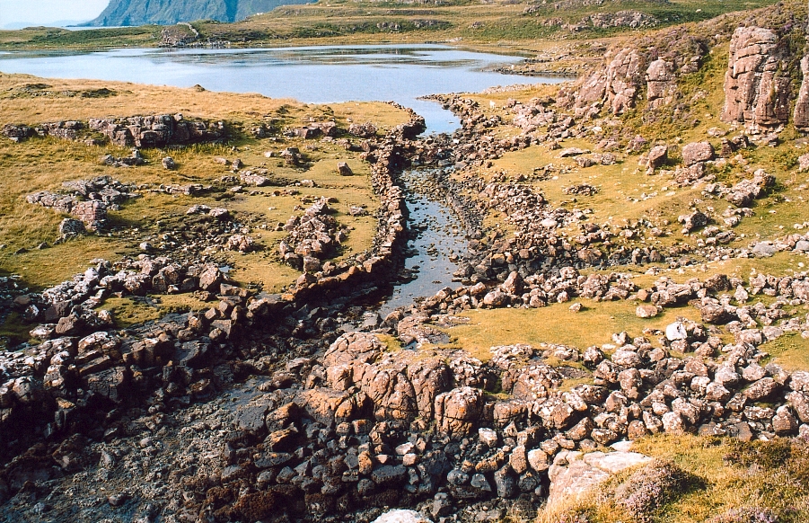
Rubha an Dùnain is best known among Viking-age enthusiasts for the maritime works clustered around Loch na h-Àirde, a small, shallow loch close to the peninsula's sea shore. A narrow artificial channel, roughly 3.5 metres wide, links the loch to the sea, and stone quays flank its inshore mouth. Alongside the canal lie two substantial boat noosts, or nausts: hollowed berths where vessels could be drawn up, over-wintered and maintained. Because the loch is fed by a system holding its water level steady, archaeologists interpret the whole arrangement as a sheltered harbour for clinker-built craft such as the birlinn.
The dating rests on hard evidence as well as tradition. In 2000 a local archaeologist recovered an oak boat timber from the loch, later lodged in Inverness Museum and radiocarbon-dated to around AD 1100, placing active use firmly in the Norse and Norse-Gaelic period when the Hebrides lay under Scandinavian influence until they passed to Scotland in 1266.
The improvements are traditionally credited to the Vikings, though the harbour's long life also reflects the MacAskill kindred, a sept of Clan MacLeod associated with the headland into the later medieval period. Historic Environment Scotland recognised the harbour, docks, canal and loch as a rare medieval complex of national importance, formally scheduling the wider landscape in 2017. Around it stand far older monuments, including a Neolithic chambered cairn and an Iron Age promontory dun.
Hva du får se
There is no signage, ticket office or reconstruction here; the appeal is the setting and the fabric itself. Walkers reach a low, treeless headland beneath the Cuillin, where Loch na h-Àirde sits just above the shore. The most striking feature is the stone-lined canal cutting from the loch toward the sea, with the remains of quays at its seaward mouth and two boat noosts, shallow stone-edged berths, alongside. On a promontory nearby are the tumbled walls of an Iron Age dun commanding the seaward approach, and inland a well-preserved Neolithic chambered cairn with its passage still visible. Ruined stone buildings and field boundaries nearby recall the MacAskill township abandoned by the time of the later-nineteenth-century clearances. Views south and west take in Rùm and Canna, the nearest of the Small Isles, across the water.
Besøk
Rubha an Dùnain is reached only on foot, by a roughly 13-kilometre return walk from the Glenbrittle campsite at the road-end in Glen Brittle, south-west Skye; the nearest villages are Carbost and Portnalong. The route is a rough, boggy moorland path with no facilities, so come equipped for changeable Highland weather and allow the better part of a day. The site is open, unstaffed and free to visit, with no visitor centre. It is a scheduled monument, so leave all structures undisturbed. For current access advice, land information and its protected status, consult the Historic Environment Scotland and Highland Historic Environment Record pages listed in the sources before setting out.
Kilder